


StanleyPermanent marker FatMax (0-47-314) Stanley
Leave clearly legible marks on wood, metal and masonry for marking out cuts and holes.

The CountryMapper airborne hybrid sensor Leica is intended for professional use in the following contexts:
Laser and surveying instruments include laser distance meters, laser levels, rotary lasers, GNSS receivers and machine control systems, with tripods and accessories, for measuring and setting out.
Used for topographic surveying and site setting-out.
Set the instrument on a tripod or stable base, away from vibration, and let it self-level or level it manually. Before starting, check accuracy against a known reference and, outdoors, use the detector or staff to read the beam. Never look into the laser beam, and transport the instrument switched off in its case.
Designed for surveyors.
Reference standards: CE marking in accordance with the EU directives applicable to the airborne systems sector, compliance with the technical and safety standards in force, technical documentation supplied by the manufacturer Leica.
Airborne hybrid sensor CountryMapper Leica (Leica) — The world's first hybrid sensor for large-area imaging and LiDAR data collection, leveraging Leica Geosystems' leadership in hybrid airborne technologies.
In your request, please state the length, the power rating and the quantities required, so we can give you the right quotation first time.
For prices and availability, request a quote from AMES Srl: we will reply with our quotation, delivery times and, where needed, an equivalent technical alternative.
| Dimensions (mm) | height 770, diameter 408 (lower) / 435 (upper) |
|---|---|
| Weight (kg) | 55 (sensor); < 104.8 (installed system) |
| Laser wavelength (nm) | 1.064 |
| Pulse frequency | up to 2.0 MHz |
| LiDAR field of view | 10-60° programmable |
| Flight altitude (m AGL) | 300-6.000 |
| Laser class | 4 |
| Accuracy | vertical < 5 cm, horizontal < 13 cm |
| Operating temperature (°C) | da -10 a +35 |
| Average power (W) | 870 a 28 V DC |
Technical data declared by the manufacturers. An empty cell means the figure is not declared.
| Feature |
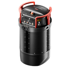 This model
Hybrid airborne sensor CountryMapper Leica |
 Linear-mode LiDAR sensor TerrainMapper-3 Leica |
 High-performance urban mapping sensor CityMapper-2 Leica |
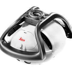 Airborne imaging and LiDAR system MultiMapper Leica |
|---|---|---|---|---|
| Brand | Leica | Leica | Leica | Leica |
| Dimensions | height 770, diameter 408 (lower) / 435 (upper) | height 757, diameter 408 (lower) / 435 (upper) | height 745, diameter 408 (lower) / 435 (upper) | 530 x 360 x 340 (L x P x H) |
| Weight | 55 (sensor); < 104.8 (installed system) | 47.6 (sensor); < 97 (installed system) | 57.5 (pod) | < 25 (pod with eFrame); < 35 (complete system) |
| Laser wavelength | 1.064 nm | 1.064 nm | 1.064 nm | 1.052 nm |
| Pulse frequency | up to 2.0 MHz | up to 2.0 MHz | up to 2 MHz | up to 2.0 MHz |
| LiDAR field of view | 10-60° programmable | 10-60° programmable | 20-40° | 10-58° |
| Flight altitude | 300-6,000 m AGL | 300-6,000 m AGL | 300-5,500 m AGL | up to 1,200 |
| Laser class | 4 | 4 | — | 3B |
| Average power | 870 a 28 V DC | 800 a 28 V DC | 811 a 28 V DC | — |
| View product → | View product → | View product → |
Everything you need in one place, from functionality to safety.
Leave clearly legible marks on wood, metal and masonry for marking out cuts and holes.
We use essential cookies to make the site work, and, only with your consent, analytics and marketing cookies to understand how it is used and to offer you relevant content. You can change your mind at any time. Read the privacy policy
For purchasing offices and MRO buyers
Search by task
Thank you! Your request has reached one of our buyers: we'll reply within 24 working hours with the quote or with any questions needed to complete it.